
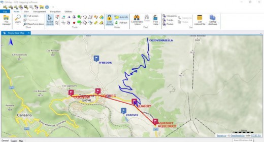
Description: OkMap is a suite of cartographic applications (for Windows, iPad, iPhone) for professional activities in the field, outdoor sports, and your enjoyment in the nature (search and rescue, trekking, mountain bike, 4WD, geocaching and much more).
Features:
Characteristics
• Display web maps for more than 40 servers
• Ability to add new custom web map servers
• Calibration / display raster maps (over 30 image formats) (video)
• Display vectorial maps
• Display hybrid maps (raster + vectorial data)
• Ability to open multiple maps simultaneously
• 10 cartographic projections of the most used
• Representation of coordinates in: degrees, degrees-minutes, degrees-minutes-seconds, UTM, ECEF, Georef, US National Grid, British
Grid (Ordnance Survey National Grid), Irish Grid, metric coordinates with custom projections
• Database with over 3000 predefined projections by geographic area
• Database with over 700 datum
• Viewing 3D raster maps on Google Earth (for supported image formats)
• Night vision
• Map add-ons management (icons, comments)
• Vectorial data management (point, multipoint, line, polygon)
• GPX data management (waypoints, tracks, routes)
• Files manager
• Selecting multiple objects with the mouse
• Context menu (right mouse)
• Auto-info function
• Zoom, autofit functions
• Moving map function in 3 modes
• Docking forms
• Customizing toolbar
• Showing yes / no toolbar
• Showing yes / no statusbar
• Check new releases at startup
GPX data (waypoints, routes, tracks)
• Creating / moving GPX data with the mouse (video)
• Create tracks in "free hand" mode
• List waypoints, routes, tracks and edit attributes
• Deleting GPX data
• GPX data search
• Track statistics with more than 30 indicators
• Track altitude profile and other 7 types of graphs
• Track simplification
• Track smoothing
• Track altitudes smoothing
• Duplicate track / route
• Join tracks / routes
• Join track segments
• Divide track in multiple segments
• Divide track in multiple tracks
• Set DEM altitude to waypoints, routes and tracks
• Loading GPX data recently opened
• Download waypoints from OpenStreetMap
Vectorial data (point, multipoint, line, polygon)
• List vectorial themes and attributes management
• Create / move vectorial data with the mouse
• Edit vectorial data attributes
• Delete vectorial data
• Import vectorial data from ESRI data shapes
• Download vectorial data from OpenStreetMap
Toponyms
• Import the toponyms from different sources (OziExplorer, Garmin POI, GPX)
• Create toponyms with the mouse
• Up to 3 classification types and altitude
Photos
• Create your own list of photos
• Automatically manages all major image tag
• See pictures drawn on the map
• Show the orientation of the taken picture
Map add-ons (icons, comments)
• Creating / moving map add-ons with the mouse
• Edit map add-ons attributes
• Deleting map add-ons
Maps management
• Compute distances and areas on the map
• Minimap display (thumbnail)
• Magnifying lens display
• Indexing / list / open maps
• Meta/map display function and show map boundary
• Search maps function
• Map image print / save / copy to clipboard
• Saving location / zoom of the map on close
• Loading maps recently opened
• Maps conversion from a format to another
Grids
• Displaying latitude / longitude grid
• Displaying metric grid (alternative projection)
Altimeter data
• Using SRTM DEM data
• Altitude display on the current mouse position
• Automatic download of DEM data relating to current map
• Showing DEM data boundaries on the map
Map tiling
• Output formats: Garmin custom maps, KML, KMZ, JNX, OruxMaps, TomTom map overlays and OkMap (video)
• Automatic or manual setting of tiles number and size
• Optimizing for Garmin custom maps and OruxMaps
• Choice of tiles to generate
• Orient the map to the north
• Crop the map image
• Resize the map image
Google integration
• Downloading and saving maps from Map Servers with automatic calibration
• Google Maps viewing integration
• Google Earth viewing integration (map + GPX data)
Web services functions
• Autorouting function
• Geocoding function
• Search geocache function
Calculation and conversion features
• Integration with GpsBabel front-end
• Conversion GPX data to vectorial data
• Conversion vectorial data to GPX data
• Coordinate conversion functions
• Coordinate conversion batch functions
• Distances and azimuth conversion functions
• Distances calculating functions
• Areas calculating functions
• Grid generator for research teams
Communication with the GPS
• Send GPX data to GPS devices (DeLorme PN20/30/40, Garmin, Magellan, NaviGPS GT-11/BGT-11)
• Receive GPX data from GPS devices (Brauniger IQ series, DeLorme PN20/30/40, Garmin, GlobalSat DG-100/BT-335, Holux M-241, Magellan, MTK Logger, NaviGPS GT-11/BGT-11, SysTraq Venus, Wintec)
Navigation
• NMEA 0183 navigation
• Automatic map centering during navigation
• Automatic switching from one map to another
• Display data navigation
• Display data on satellites in view
• Recording the "active log" track in real time
• Storing waypoint in real time (man overboard)
• Navigation toward a waypoint
• Navigation along a route
• Navigation along a track
• Waypoint proximity alarm
• Anchor alarm
Remote devices and servers
• Send tracks to remote OkMap and GpsGate servers
• Receiving and viewing tracks in real time from OkMap, EasyTrails and OruxMaps remote devices
• Receiving and viewing tracks in real time from GpsGate remote server
Potential use
• Search and rescue
• Trekking
• Mountain bike
• Off road
• Boating
• Flying
• Hunting and fishing
• Finding mushrooms
• Geocaching
• Soft air
Supported formats
• Images: ECW, BMP, GIF, JPG, PNG, TIF and many others
• Load maps: GFW, JGW, PGW, TFW, BPW (World file); ECW (Earth Resource Mapping - map with UTM projection are automatically georeferenced); KML/KMZ (Google Earth, Garmin Custom Maps); JNX Birdseye (one level, small maps); GeoTiff; OziExplorer; CompeGps; GPS TrackMaker; RMap; MBTiles; OruxMap; GpsTuner
• Save maps: GeoTiff; World file; Garmin custom maps; KML/KMZ; JNX Birdseye; OziExplorer; OruxMaps; TomTom map overlays; GpsTuner
• Maps tiling: Garmin custom maps; KML, KMZ, JNX, OruxMaps, TomTom map overlays and OkMap
• Vectorial data: SHP, DBF (Esri shape file); DCW (Digital Chart of World)
• GPS data: GPX; CompeGPS, EasyGPS, Fugawi, Garmin, Geocaching LOC, Google Earth (KML/KMZ), GPS TrackMaker, OpenStreetMap, OziExplorer and many others formats thanks to the software GpsBabel
• DEM data: HGT (SRTM-1 and SRTM-3)
Supported GPS devices
• Upload/download: all new GPS devices that are handled as a mass storage device + Brauniger IQ series, DeLorme PN20/30/40, Garmin, GlobalSat DG-100/DG-200/BT-335, Holux M-241, Magellan, MiniHomer, MTK Logger, NaviGPS GT-11/BGT-11, SysTraq Venus, Wintec WBT-100/200
• NMEA navigation: all GPS devices that support Nmea 0183 protocol
Supported Languages:
- English
- French
- German
- Italian
- Slovenian
- Spanish
Release Name: OkMap Desktop 17.11 (x64) Multilingual
Size: 43.7 MB
Links: HOMEPAGE – NFO – Torrent Search
Download: FiKPER – UPLOADGiG – NiTROFLARE – RAPiDGATOR