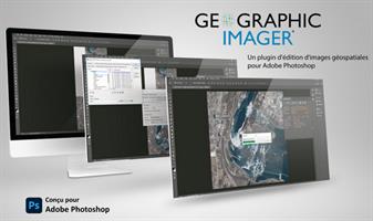
Description: Working with raster imagery doesn't have to be complicated. Geographic Imager® enhances Adobe Photoshop to make working with spatial imagery quick and efficient. It adds tools to import, edit, manipulate and export geospatial images such as aerial and satellite imagery. Enjoy the use of native Adobe Photoshop functions such as transparencies, filters, pixel editing, and image adjustments like brightness, contrast, and curve controls while maintaining spatial referencing.
Transform
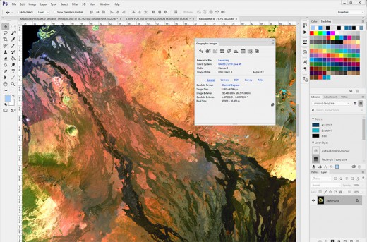
Extensive support for thousands of geographic and projected coordinate systems. Easily transform between geodetic and projected coordinate systems. Need to define your own coordinate system? Create one or edit an existing definition and save it for future use. Manage custom transformations in an easy to use coordinate system browser.
Georeference
Georeference images easily by adding ground control points. Manually add control points, import or export points from a text file, and view accuracy and errors. Use the Quick Georeference option to make georeferencing even easier. Multiple transformation types are supported.
Mosaic
Snapping images together not working? Mosaic individual images to create a seamless image. Retain images as separate layers or flatten to create one image. Images mosaicked together retain spatial referencing and can be individually modified using Adobe Photoshop tools or transformed using Geographic Imager.
Tile
Forget the Slice tool. Tile an image into multiple images by tile size or count and automatically save them using sequential naming. Tiles retain spatial referencing making it ideal to import into MAPublisher without any trouble.
Geographic Imager 3.0 features and additions
64-bit support - Geographic Imager is now supported on Adobe Photoshop CS4 64-bit for Windows XP/Vista/7. Open larger images and greatly improve Adobe Photoshop and Geographic Imager performance.
New supported image formats - Several new formats are supported: BIL, NITF and BigTIFF. See all Geographic Imager supported formats.
Georeference - Several enhancements were made to the Georeference tool. The ground control points can now be specified in their own coordinate system within the Georeference dialog box. The Quick Georeference functions has an additional option to load the reference of another file. New customizing options have been introduced such as control point and label colours. A tool to remove georeference has been added
GeoCrop - New and improved GeoCrop and GeoCrop Import user interface. It now includes a crop image preview. Draw a crop marquee, use point proximity or specify pixel, geodetic or projected coordinates or to define a crop area quickly and easily.
Digital Elevation Model (DEM) Schema - DEMs provide an effective method of storing information for a continuous surface. DEM data needs to be rendered, so it can be displayed visually. Depending on what type of DEM data it is and how it should look, the type of rendering schema needs to be customized or automatically assigned.
Tiled images can now be saved to any image formats supported by Adobe Photoshop
Automating tasks - All functions provided by Geographic Imager are now fully compatible with scripts and actions, and can be scripted or recorded to easily automate repetitive tasks.
Licence management - New licensing management system. Easily manage license options including commercial, academic, multi-user and floating.
Various other user interface improvements and performance enhancements to improve usability.
What's new in Geographic Imager 3.4?
Fully compatible with Adobe Photoshop CS5.1 (also known as Photoshop 12.1 in Adobe CS5.5) in both 32 and 64 bit
New import support for ERDAS IMAGINE (.img), Esri ArcInfo Binary Float Grid (.flt), and "DEM" grayscale GeoTIFF (*.tif) formats, including ability to import georeferenced images from Web Map Service (WMS) sources
New export support for BigTIFF, ECW (up to 0.5 GB), and NITF formats
Major enhancements to Advanced Import, including options to:
import multiple files of differing formats
resample and crop images prior to import
modify bands/channel color mapping and select specific channels to import for multiband/hyperband images
mosaic and import images as layers into existing documents specify and adjust DEM and DTM information and combine multiple DEM files on import
Enhanced Quick Save feature for quick format conversion
New ability to measure areas in images using the Adobe Photoshop Measurement Log panel
Various bug fixes and user experience enhancements
Release Name: Avenza Geographic Imager for Adobe Photoshop 6.6.1
Size: 367.2 MB
Links: HOMEPAGE – NFO – Torrent Search
Download: FiKPER – NiTROFLARE – RAPiDGATOR